Big Bend National Park Information Guide

Welcome to the Big Bend National Park Information Guide.
Here you will find all you need to know about the natural history of the park.
Learn about the geology, trees, mammals, birds, or other plants and wildlife of the area.

-SPONSORED LINKS-
Big Bend Lodging
Big Bend Hotels
Big Bend Maps
Big Bend Camping
Big Bend Weather
Big Bend Vacation Rentals
Fruited Prickly Pear - Corel ©

Sponsored National Park Search

Big Bend National Park Information

  • Establishment
  • Flora & Fauna
  • Geology
  • History
  • Index
  • Size & Visitation

  • 
    

    Establishment

    In 1933, the state of Texas established Texas Canyons State Park, using 15 school sections owned by the state. Lands forfeited for non payment of taxes were quickly added and the name was changed. By October 27, 1933, Big Bend State Park included about 160,000 acres. In 1935, on June 20, President Franklin D. Roosevelt signed a bill that authorized the establishment of Big Bend National Park. On June 6, 1944 a deed for about 700,000 acres was formally presented to President Roosevelt and Big Bend was established June 12, 1944 as a National Park by Congressional Act signed by President Franklin D. Roosevelt. It was designated an International Biosphere Reserve in 1976.


    Size and Visitation

    Big Bend National Park is a land of borders. Situated on the boundary with Mexico along the Rio Grande, it is a place where countries and cultures meet. It is also a place that merges natural environments, from desert to mountains. It is a place where south meets north and east meets west, creating a great diversity of plants and animals. The park covers over 801,000 acres of west Texas. For more than 1,000 miles, the Rio Grande forms the international boundary between Mexico and the United States; Big Bend National Park administers approximately one-quarter of that boundary. Within the 118 twisting miles that also define the park’s southern boundary, the river’s southeasterly flow changes abruptly to the northeast and forms the “big bend” of the Rio Grande.

    Big Bend National Park is open year round. But the majority of park visitors come March and holiday weekends, lowest visitation is in August and September. The park is open 24 hours a day, seven days per week.

    With an average of 350,000 or less visitors a year, Big Bend National Park is lightly visited, however for those that do, they find, clean air and plenty of sunshine, as well as many opportunities to hike and enjoy the outdoors.


    History

    The Indians said that after making the Earth, the Great Spirit simply dumped all the leftover rocks on the Big Bend. Spanish explorers, less intimate with the landscape, merely dubbed this "the uninhabited land." To come to know this land of desert and mountains cut through by the Rio Grande, the big river, is but to grasp a larger appreciation of the unknown.

    Prehistoric Native Americans made their homes here at least 10,000 years ago and perhaps earlier, but little evidence of human occupation appears until the Archaic or Desert Culture of 6,000 BC. These people were not farmers but hunters and gathers who took only what this country offered on its own.
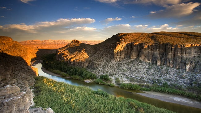
    Hundreds of Chihuahuan Desert plants were useful to prehistoric people for food or medicine. Their diet included the heart of the sotol and lechuguilla plants; the fruit and blossoms of yucca; the fruit and young pads of pricklypear; mesquite and acacia beans; and many other native plants. They fashioned baskets and sandals from lechuguilla fiber and yucca leaves. For hunting they used the atiati, a throwing stick that propelled stone-tipped darts to kill deer, rabbits and other game. Like us they needed not only food but valuable sources of drinking water, and today, living sites often include the remnants of rock shelters and hearths or fire rings. In the later part of the Archaic Period, trade between the local people and those from the south and west introduced horticultural practices, bringing cultivated corn, beans and squash to supplement their diets. By 1200, the La Junta people, an agricultural group related to the Puebloan people of the upper Rio Grande, occupied and farmed the river floodplain in areas west of today's national park. In the 1500s, the Spaniards enslaved the Native Americans and substantially changed their culture. Spanish explorers crossed the Rio Grande in the 16th and 17th centuries in their search for gold and silver and fertile lands. The Presidio del Paso de San Vicente was established in 1774 at a major crossing on the Rio Grande. People did not attempt floating the river, as far as we know.

    Apaches moved in sometime in the 1700s, pushed southward by the Comanches. The Comanche Indians also crossed the river during the 19th century, traveling to and from Mexico with their raiding parties.

    The Apaches were capable of resisting the Spaniards, who in the 1700s began to release their tenuous hold of this area. In the 19th century, driven by pressures on hunting territories from encroaching Anglo-American homesteaders, the Comanches were forced southward. Mexican settlers occupied the Big Bend by the early 1800s, and their isolated communities became the targets of raids by nomadic Comanche warriors. The gold discoveries in California in the mid-1800s and the destruction of the bison herds hastened the Comanches' decline. Military forts were built along the route that passed through this area to California goldfields.

    Exploration of the river itself came only in 1852, with a boundary survey conducted by U.S. Army Major William H. Emory. The Emory party examined all three canyons but elected to float only Mariscal. In 1881, a survey party led by a Texas Ranger floated Santa Elena Canyon. The leader actually led his party by horse from the canyon rim. In 1889, a U.S. Geological Survey expedition became the first group to run Boquillas Canyon. Some farming had been done on the river's floodplain starting with Mexican settlers on both banks around 1900. Anglo-Americans joined in the farming after 1920, when the Mexican-American boundary unrest ended. Cotton and food crops were grown around Castolon and what is now Rio Grande Village even after the park was established in 1944.


    Geology

    The geologic history written in the rocks of Big Bend National Park reveals an ever changing and eventful past. While the oldest time periods of earth are not represented in the rocks of the park, there is abundant evidence of the eras when life rose and thrived - the Paleozoic, Mesozoic, and Cenozoic.

    Most of the rock exposed in Big Bend is sedimentary in nature. Sedimentary rocks are those deposited as dust, sand, mud, or animal skeletons that have subsequently hardened. Limestone, sandstone, and shale are common sedimentary rock rocks in Big Bend. Many were deposited during the Cretaceous period, which lasted from about 145 to 65 million years ago. Much of what we call West Texas was covered by salty seas for most of that time. The skeletons of countless marine animals accumulated along with lime mud on the ocean floors, gradually hardening into thick layers of limestone that make up the walls of Santa Elena and Boquillas canyons.

    More recent layers of rock, exposed in Tornillo Flats, contain the fossils of ancient mammals that hunted and browsed in tropical swamps and forests in early Tertiary time.

    Perhaps the most striking geological feature in the park is the range of mountains called the Chisos. Tising abruptly out of the sedimentary plains, it's easy to see that these jagged peaks are volcanic in nature.

    Big Bend National Park can be thought of as having three natural divisions; the river, the desert and the mountains. River and mountains serve as counterpoints to the desert. The river is a linear oasis. The mountains function--in relation to their arid surroundings--much like an island of temperate life.

    The River

    The name Big Bend refers to the great U-turn the Rio Grande makes here in Southwest Texas. The river is an arching linear oasis, a ribbon of green strung across the dry desert and cutting through its mountains. As do all rivers that survive desert passages, the Rio Grande has its headwaters outside this desert. Today, much of the water flowing through the park is supplied by the Rio Conchos, flowing out of Mexico, and not by the Rio Grande. Much of the flow of the Rio Grande is diverted for irrigation or lost to evaporation before reaching the park's western boundary. The Rio Grande defines the park's southern boundary for 118 miles. The garfish and some turtles in the river are living fossils that help describe its former life as a lush savannah and swamp 50 million years ago. Their ancestors swam in company with crocodiles and hippopotamus-like creatures.

    If you wonder about the river's carving power, did it really cut such colossal canyons?--paddle an aluminum canoe down the Rio Grande. The canoe will seem to hiss as thousands of abrasive particles bounce off its hull. The river is like a relentless, gravity-powered belt sander that has been running for millions of years.

    Among the most startling sights in this desert country may be the tooth marks of beaver on cottonwood or willow trees along the river. But don't look for beaver lodges. The beaver in the Big Bend live in bank burrows. The river is an oasis for species not adapted to the aridity of desert life, and so it adds to the park's biological diversity.

    The river floodplain provides good areas for birdwatchers. Some birders maintain that the birds in the floodplain are more colorful than elsewhere. Here you find summer tanagers, painted buntings, vermilion flycatchers and cardinals serving as accent colors to the background greens of floodplain foliage. This ribbon-like floodplain verdancy, seen from a distance, appears as a green belt in the desert. It is a phenomenon seen elsewhere in the park along arroyos, or washes. Undoubtedly you will find birds and other animals making ample use of this interruption of more arid desert vegetation.

    On the river's gravel and sandbars and on its cliffbanks are other creatures you would not expect to find in the Chihuahuan Desert. The sandpiper and killdeer bob and sprint on the sandbars, and the cliff swallow flies up to its adobe nest fashioned of river mud.


    The Desert

    North America has four warm deserts: Great Basin, Mojave, Sonoran and Chihuahuan. The Chihuahuan extends deep into Mexico. Big Bend National Park lies in the northern third of the Chihuahuan Desert. This desert is bordered on three sides by mountains that block the rains. The fourth side abuts vast semiarid plains. The Chihuahuan Desert is young, perhaps not more than 8,000 years old. It is also a green and somewhat lush desert that receives most of its rainfall during the summer months when it is needed most. The chief indicator plant of the Chihuahuan Desert is lechuguilla, appearing as a clump of dagger blades protruding from the desert floor. The coarse, strong fibers of the lechuguilla are used in matting, ropes, bags and household items, which are, in a way, products of the Chihuahuan Desert. The lechuguilla illustrates an often misunderstood fact about the desert: the desert is a life zone. Life has adapted here to minimize expending its energy and to maximize getting or even hoarding water, as the kangaroo rat illustrates.

    Heat and seasonal winds contribute to the aridity. At mid-day in summer, ground temperatures may reach 180° F, or it can be freezing cold in winter when northern storms sweep through. The good news is that it is often a luxurious 80° F here while the Rocky Mountains are locked in deep snow.

    Too often the desert has been conceived of as a vast emptiness. Actually the desert is a life zone full in it's own way, of plants and animals suited to their circumstances. Ecologically speaking, if they weren't suited, they wouldn't be there. The life of the desert is nowhere more apparent than amidst the astonishing floral display that may follow rainy periods. Cactuses begin to flesh themselves out to their true water retentive proportions and to sport colorful blossoms. Dead looking plants leaf out anew. Wildflowers galore bloom as carpets of glorious color. Perhaps nothing can revise so thoroughly your concept of the desert as to witness its flowering.


    The Mountains

    If the Rio Grande interrupts the Big Bend country as a linear oasis, the Chisos Mountains interrupt it as a green island in a desert sea. As does the river, the mountains bring creatures you might not expect to find in desert areas, and several species are quite rare. Isolation provided the key. This situation was set in motion thousands of years ago as the Great Ice Age drew to a close. As the colder, moister climates retreated northward, many plants and animals became stranded in the Chisos Mountains by the lowlands' increasing aridity.

    Carmen Mountains white-tailed deer provide a graphic example. Within the United States, these deer live only in the Chisos Mountains. They also occupy several of the nearby mountain ranges in Mexico but are not known to occur outside this area that the Rio Grande bisects. White-tailed deer are not adapted to desert conditions. They may have had a much wider range in this region during the Ice Age, when its climate was cooler. As the climate warmed, cooler conditions prevailed in the mountains because of their higher elevations. Today, the fate of this smaller white-tailed deer can be monitored by watching the desert mule deer gradually encroach on mountain foothills. Adapted to desert life, mule deer appear to be usurping some of the white-tail deer's range.

    Average rainfall at the Basin, a Chisos Mountains location popular with people and other animals, is twice that at Rio Grande Village along the river. Approaching the mountains through Green Gulch, you pass grasslands punctuated by century plants and sotol, but soon notice green, leafy shrubs. Then the bushes get taller, with evergreen sumac, mountain mahogany, Texas madrone and common beebrush. You see both evergreen and deciduous leaves. When you attain an elevation of 4,500 feet, the first tall trees begin to appear. Higher up in the drainages you see masses of trees--junipers, small oak trees and pinyon pines. Some tree species found in the Chisos Mountains grow there at the extreme southern limit of their ranges in the United States: Arizona pine, Douglas fir, Arizona cypress, quaking aspen and bigtooth maple. These are the last lingering remnants of forests once widespread here under the influence of the Ice Age.

    Some Big Bend plant species are found nowhere else in the world. The Chisos oak grows only in the Chisos Mountains highcountry. A number of other plant species grow in the United States only in the Chisos Mountains but also are found in Mexico and elsewhere. The drooping juniper that looks like it needs a good watering is such as plant.

    To see all the bird species that occur in the United States, eventually you must come to the Chisos Mountains to see the Colima Warbler. It nests here after wintering in Mexico. Also occurring here is the mountain lion, locally called a panther. This cat has given its name to the lion's share of park places, including Panther Pass and Panther Junction.


    Flora and Fauna

    In Big Bend National Park, there are:

    • 450 Bird Species
    • 75 Mammal Species
    • 67 Amphibian and Reptile Species

    Amazing Adaptations

    The popular image of desert-dwelling plants is the cactus, uncommonly adept at getting water and then miserly about hanging onto it. There are other strategies or adaptations. One is waiting. Many desert annuals, unlike their counterparts in temperate climes, simply wait out the rains in their seed stage of life. It the rains don't come one year, the seed simply remains dormant. Some seeds are coated with chemicals that inhibit germination. Unless enough rain falls to remove the inhibitor, the seed ignores the wetting. This assures that the developing plant will have enough water to complete its life cycle and develop new seeds before the next dry spell. This chemically patient seed may wait more than a year to germinate, but once it does, the plant will develop, flower and fruit much more rapidly than a temperate annual would.

    Creosotebushes ply another strategy. These regularly spaced shrubs look as though human beings had planted them because they produce a toxin in the leaves that, when shed, discourages other plants from intruding on their growing space. The small creosotebush leaves are coated with a resin so that they lose little moisture to the air. These combined strategies make creosotebush the most prevalent shrub in the park and enable it to prosper in all North American deserts. Creosotebushes that grow along a road, tap pavement runoff and may grow twice as tall as those one row back from the road.

    Cactuses exemplify water conservation. Instead of water-losing leaves, cactuses have spines. These also protect the plants from being trampled or eaten (when you're all stem, you can't afford to be nibbled on!). The thick and fleshy stem presents reduced surface area and bares a waxy coating that inhibits evapotranspiration. The shallow root system spreads in a wide pattern to intercept rainwater as soon as it enters the ground. Cactuses store water, serving as their own reservoirs and surviving long droughts.

    The ocotillo, not a cactus, is in a family by itself. With rain, the ocotillo develops leaves but drops them when dry conditions return. This may happen several times per year.

    Wax extracted from the candelilla, or wax plant, is used in the manufacture of candles, waxes, gum and phonograph records (ask you parents what these are). In the rainy season, the stem fills up with a thick sap that, in the dry season, coats the stem as a wax and prevents evaporation. The wax seals in moisture and protects the candelilla from drought.

    Desert plants display their most profuse flowering in late summer, following the regular rains of July and August. While this is difficult to predict, wildflowers often are most impressive during the hot months. One glimpse of this floral richness may change your image of the desert forever.

    We should not be amazed that Big Bend animals are so curiously and so well adapted to the desert life. Such adaptations are what life is all about. There are fairy shrimp, fast-growing toads and those jackrabbit ears. There are more mundane adaptations, too. Many animals beat the heat by coming out only at night. Most snakes do this because summer daytime temperatures on the desert floor would kill them in minutes. Another simple way to beat this heat is to climb above it. Many human travelers pass through the summer desert quickly, headed for the higher and cooler Chisos Mountains. Some insects use the same principle. They merely fly straight up in the air a short distance, where it is significantly cooler. One walking beetle seems to rise up on stilts periodically, again to achieve critical distance from the desert floor's killing heat.

    Jackrabbit's big ears are its distant early warning system against predators. The ears also are used as radiators to transfer excess body heat to the environment as necessary.

    The kangaroo rat is superbly adapted to dry desert life. It need never drink to survive. It can metabolize water from carbohydrates in the seed, and it eastes no excess moisture.

    The roadrunner runs at speeds up to 20 mph in persuit of lizards and small rattlesnakes. These it pecks to death with stunning blows of its beak. The roadrunner gets much of its required moisture from the body fluids of its prey.

    The golden eagle's wingspread may be 6 to 8 feet. It's golden nape is visible only at close range. It nests in large trees or on high rocky ledges and feed mostly on rabbits and large rodents.

    The coyote can put on a burst of speed sufficient to run down jackrabbits. Its craftiness, immortalized in many Native American myths, sometimes is witnessed by wildlife watchers.


    Big Bend National Park Travel Packets

    Big Bend National Park Links
    Bullet Activity & Calendar Page
    Bullet Address, Email & Phone Guide
    Bullet Backcountry Camping
    Bullet Backpacking
    Bullet Biking
    Bullet Boating
    Bullet Brochures, Maps, Written Info
    Bullet Camping Guide
    Bullet Chat
    Bullet Establishment
    Bullet Fees
    Bullet Fishing
    Bullet Flora & Fauna
    Bullet Geology
    Bullet Hiking Guide
    Bullet History
    Bullet Jobs, SCA, Volunteer Positions
    Bullet Junior Ranger Programs
    Bullet Location
    Bullet Lodging Guide
    Bullet Map Guide
    Bullet Mountain Lion & Black Bear
    Bullet Park Information
    Bullet Pet Information
    Bullet Poisonous Reptiles & Insects
    Bullet River
    Bullet Search
    Bullet Sights Guide
    Bullet Size & Visitation Info
    Bullet Swimming
    Bullet Travel Guide
    Bullet Visitors Guide
    Bullet Weather

    Big Bend National Park
    Texas National Parks Page
    Back to National Parks


    by John William Uhler

    Copyright © 1995 - 2007 Hillclimb Media

    This site is in no way associated with the United States Government, the Department of the Interior or the National Park Service

    Demand Media Knowledge